




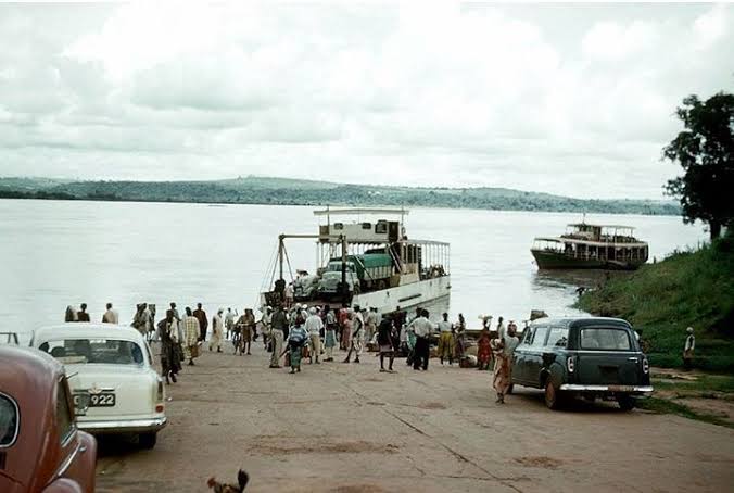
Long before the towering arch of the Niger Bridge connected Onitsha and Asaba, a different system of crossings anchored daily life and trade across the River Niger. For decades, the Onitsha-Asaba ferry stood as a crucial artery, linking the burgeoning road networks of Nigeria’s eastern and western regions.
This was more than just a passage; it was a lifeline for trade, transport, and migration. It facilitated the movement of people, goods, and vehicles, including heavy trucks, across one of West Africa’s most formidable natural barriers. Its story reveals how Nigeria’s physical landscape was gradually reshaped to serve its growing economic ambitions.
River Niger: Nigeria’s Enduring Inland Highway
The River Niger has always been a fundamental highway for communities along its banks, long predating the arrival of motor vehicles. Traders and farmers used canoes to move people, farm produce, and various goods between settlements and bustling markets.
Onitsha, positioned strategically on the eastern bank, grew into a significant commercial hub. Its connections extended across the river towards Asaba and into territories west of the Niger. These traditional river craft were an indispensable part of daily movement between the two shores.
From Canoes to Early Colonial Transport
The scale of these riverine operations began to shift dramatically during the colonial era. Historian Anthony Danladi Ali records that the colonial government established the Government Marine Department in 1901.
This institution was responsible for water transport, leading to government launches operating on Nigerian waterways. Private trading companies also deployed steamers and other powered vessels, marking an upgrade from solely traditional methods. Canoes, however, remained an essential part of local transport.
But the true challenge arrived with the motor vehicle. Moving a person across the river in a canoe was one thing; transferring a car or a fully loaded lorry presented an entirely new problem. As Nigeria’s road network expanded, the Niger increasingly became a physical break in journeys that otherwise flowed seamlessly by road.
Geographer Reuben K. Udo recorded a crucial step forward: a government motor launch introduced at the Onitsha crossing in 1927. This development signalled a pivotal transition from rudimentary canoe transport to organised, motorised ferry operations capable of handling vehicles.
The Onitsha-Asaba Ferry System Takes Shape
By the 1930s, motor-ferry operations were established at Onitsha, marking a new era for river crossings. These services transported both government and privately owned vehicles across the River Niger, transforming how goods and people moved between regions.
The surviving figures demonstrate the ferry’s rapid importance even then. In 1935, the Onitsha-Asaba ferry carried 1,342 vehicles. In 1936, another 1,432 vehicles were transported, giving a combined total of 2,774 vehicles in just two years.
This burgeoning operation also proved a source of revenue for the colonial administration. The Marine Department received £1,611 from ferry operations at Onitsha in 1935. A slightly higher £1,730 came in 1936, illustrating an organised transport service for motorists.
Scaling Up to Meet Mounting Demand
As traffic volumes swelled, the supporting infrastructure around the ferries had to evolve. Landing facilities and approaches needed to accommodate heavier vehicles. The vessels themselves had to carry loads far exceeding anything earlier river transport methods were designed to handle.
The ferry’s growing significance became especially clear during the 1940s. From May 1, 1944, the scheduled motor-vehicle ferry service increased its daily crossings from two to four. This change directly reflected the surging demand from both passengers and motorists using the system.
The service operated on working days, including Saturdays, highlighting its integral role in weekly commerce. Special journeys outside normal operating hours required official approval, demonstrating the system’s formalised nature. Ferry regulations covered vehicle charges based partly on weight, alongside established tariffs for passenger fares and freight arrangements.
Government officials on authorised business also had specific administrative procedures for using the service. These timetables, tariffs, and regulations reflected the crossing’s increasing importance within Nigeria’s overall road and river transport networks.
Connecting Commerce: The Ferry’s Role in Regional Trade
By the post-war period, the sight of vehicles queuing to cross the Niger by ferry had become a familiar feature. These ferries were engineered to accommodate various classes of motor vehicles, alongside passengers and cargo. Regulations concerning maximum weight capacity for individual ferries underlined critical operational considerations.
Reuben K. Udo later described the Onitsha crossing as the busiest ferry point on the Niger. He emphasised its immense importance as a vital link within the trunk-road connection between eastern Nigeria and the road network towards Lagos.
The economic geography of the area amplified the crossing’s significance. Onitsha had solidified its position as one of southeastern Nigeria’s major commercial centres. Asaba, on the western bank, offered crucial access towards Benin and the wider western Nigerian region.
Farmers, traders, government officials, and ordinary travellers all depended heavily on these connections across the river. Many found their lives deeply affected by national events which relied on such transport systems.
The development of government motor ferries didn’t erase traditional canoe services. Both powered ferries and older forms of river transport coexisted. Each served different segments of the travelling public and a variety of goods and purposes.
Still, in the years just before construction began on the Niger Bridge, the river crossing had undeniably become a critical bottleneck. It was a constraint within Nigeria’s increasingly road-centric transport system.
Federal Oversight and the Evolving Transport System
The ferry’s institutional status became particularly defined during the 1950s. The official Report on Nigeria for the Year 1957 recorded the Federal Department of Inland Waterways coming into operation on April 1, 1957.
This new department assumed responsibility for several services previously managed under older federal maritime arrangements. Among the government ferry services specifically listed under its purview was the Onitsha to Asaba route on the River Niger. This formal inclusion underlined the ferry’s national importance.
The department also managed other key crossings, including the route from Sapele to the Benin Road and from Lokoja to Shintaku. The Onitsha-Asaba motor ferry was thus a crucial component of Nigeria’s formal transport administration. While private companies and canoe operators continued their activities, the government vehicle ferry formed the backbone of the primary road connection across the Niger.
By the early 1960s, the sheer volume of road traffic crossing the Niger had surged dramatically. Udo recorded that, by 1964, an average of about 7,000 vehicles a month were crossing the Niger by ferry at Onitsha. This figure starkly illustrates the extraordinary growth in traffic compared to the 1,342 vehicles recorded for the entire year of 1935.
The Bridge Solution: Ending an Interruption
The ferry system had made long-distance motor travel possible across the river, bridging a gap in the road network. But every vehicle still had to interrupt its journey: leave the continuous road, queue, wait for a ferry, board, cross the Niger, and then unload on the opposite bank.
During peak demand, congestion could become severe, leading to long delays and economic inefficiencies. Similar infrastructure projects across Nigeria often sought to resolve such bottlenecks.
A permanent bridge promised a fundamentally different experience. Instead of the laborious transfer between roads and ferries, motorists could remain on the road for their entire journey. This transformation arrived swiftly in the mid-1960s, marking the end of an era for the ferry system.
The first Niger Bridge, also known as the Onitsha Bridge or Onitsha Head Bridge, replaced the ferry service. It was completed in December 1965. Feasibility studies and design considerations had been carried out by the Netherlands Engineering Consultants of The Hague, Holland (NEDECO) in the 1950s. French construction giant Dumez then undertook its construction between 1964 and 1965.
The bridge was completed in December 1965, and its ceremonial opening took place on January 4, 1966, with Nigeria’s Prime Minister, Sir Abubakar Tafawa Balewa, presiding. This event came during the final days of Nigeria’s First Republic.
Balewa was killed during the military coup of January 15, 1966, only eleven days after the bridge ceremony, underscoring the turbulent times of its creation. The estimated cost of the Niger Bridge was £6.75 million, creating a structure 1,404 meters long, with an 11-meter wide central carriageway and pedestrian walkways on both sides.
Bridging the Divide: Nigeria’s Engineering Transformation
The significance of the new Niger Bridge was immediate and profound. For the very first time, motorists could travel directly across the Niger at Onitsha without the arduous process of loading their vehicles onto ferries. A journey that had previously involved queues, loading ramps, a river passage, and unloading now became a continuous road trip, slashing travel times and boosting efficiency.
This bridge was far more than just a major engineering project; it eliminated one of the most critical transport interruptions between eastern and western Nigeria. Its construction reflected a wider trend in Nigeria’s economic management towards integrated national infrastructure.
The older ferries, particularly one named “Shanahan” which transported trucks like the one with license A6223, had played an essential role. They made long-distance motor travel possible before the bridge existed, enabling generations of travellers to cross the river. Yet, the relentless growth of road traffic eventually made a permanent crossing not just desirable, but absolutely necessary.
The importance of the Onitsha-Asaba corridor never diminished after 1966. Motor traffic continued its relentless increase, cementing the first Niger Bridge’s status as one of Nigeria’s most vital road crossings. This constant demand for improved connectivity reveals how deeply trade and movement are woven into the nation’s fabric.
More than half a century later, another major transformation occurred: The Second Niger Bridge, linking the Anambra and Delta sides of the River Niger, was formally commissioned on May 23, 2023. This second bridge stands as another chapter in the long saga of overcoming the Niger as a physical barrier to road transport.
From traditional canoes connecting isolated river communities to pioneering motor ferries, then to the first Niger Bridge, and now a second one, Nigeria has consistently sought to improve its transport systems. This progression reflects more than technological advancement.
It charts the persistent effort to unify communities, markets, and regions across one of Nigeria’s greatest natural features. What might this continuing drive for connectivity tell us about Nigeria’s path ahead?
