




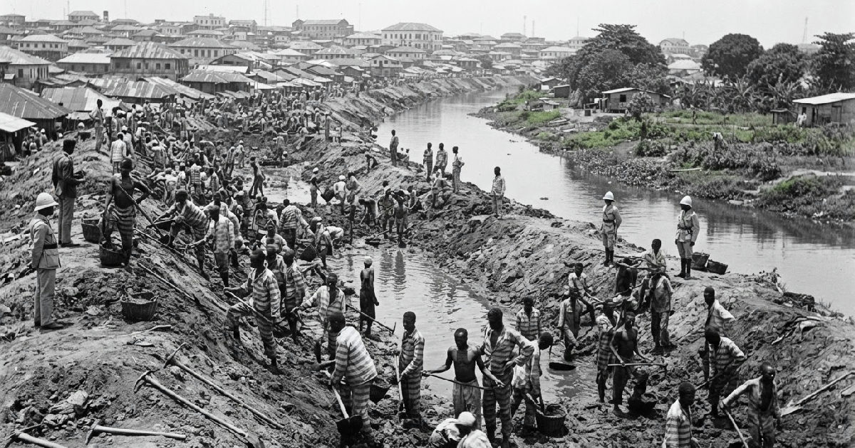
The MacGregor Canal, a 25-foot-wide artificial waterway, was cut across a narrow section of Lagos Island between 1903 and 1904 during the administration of Governor Sir William MacGregor.
This seemingly straightforward colonial project, initially intended to improve public health, did far more than drain swamps; it physically separated Lagos Island and Ikoyi, areas previously joined, and fundamentally redefined urban space and social hierarchy. The Malaria Ditch Built by prisoners was a significant undertaking.
While many might assume such a feat of engineering was merely a practical public health measure to combat malaria, its true impact stretched far beyond sanitation. It was a project rooted in controlling nature, yet it inadvertently created profound social and economic consequences that continue to echo through the city’s landscape today.
The Malaria Ditch Built by Prisoners and Public Health
This mundane canal reshaped the very identity of Lagos, turning fluid wetlands into rigid boundaries and establishing divisions that would last for generations. It wasn’t just a physical cut in the land; it was a societal cleavage, masked by the colonial rhetoric of progress and disease control, surprising in its lasting influence.
Sir William MacGregor, a Scottish medical doctor and colonial administrator, governed Lagos from 1899 to 1904. He arrived at a time when European colonial governments in West Africa were increasingly preoccupied with sanitation, particularly the fight against malaria.
The urgency of this mission became deeply personal for MacGregor; he himself nearly died from malaria in 1903, intensifying his commitment to eradicating the disease. Medical research in the late nineteenth century had firmly established the link between mosquitoes and malaria, making drainage and environmental sanitation key colonial policy.
Lagos presented an enormous environmental challenge. Much of the surrounding terrain consisted of low-lying land, lagoons, tidal flats, and vast swampy areas. These pools of slowly draining water were ideal breeding grounds for mosquitoes, and the city’s rapid growth only exacerbated these already difficult sanitary conditions, creating a dire need for intervention.
Earth, Sweat, and a New Map of Lagos
The MacGregor Canal emerged as a central solution to this problem, designed to be an important channel within a wider drainage network. Smaller drains serving the swampy ground between Lagos town and a nearby area discharged into it, using tidal movement to improve overall drainage.
What few people realise, however, is the human cost and the unexpected dual purpose of this massive undertaking. The 25-foot-wide canal wasn’t just a drainage ditch; its excavation generated vast quantities of earth, which became crucial for other colonial projects.
This excavated material was then used to reclaim the surrounding swamp land, particularly the notorious Kokomaiko Swamp. Between the 1920s and 1930s, approximately 100 hectares (250 acres) of new, usable territory in Southwest Ikoyi and Obalende had been created. This newly available land was quickly deemed suitable for roads, buildings, and development, merging public health initiatives with economic expansion.
The Labor Behind Colonial Dreams
The story of the MacGregor Canal is also a tale of unseen and often forced labour. The physical work behind the project, particularly the cutting, carrying, draining, and filling that transformed the landscape, was immense.
Prisoners from the colonial prison were employed daily on swamp reclamation work, their unacknowledged toil literally shaping the future of Lagos. These incarcerated individuals also contributed directly to the canal’s excavation itself.
Penal labor formed an important, yet often overlooked, part of the workforce that physically created modern Lagos. This reliance on forced labor adds a dark, often forgotten layer to the narrative of colonial development.
From Drainage to Demarcation
When the canal was completed, it linked significant waterways; it sliced through Lagos Island, creating an artificial boundary that proved far more significant than its sanitary function. This 25-foot-wide cut physically separated what had once been a continuous landmass.
By 1908, official descriptions of the city recognized this new division. Colonial legislation described land situated east of the MacGregor Canal as belonging to the area generally known as Ikoyi, formally separating it from the older, more densely settled Lagos Island.
A bridge was soon constructed over the canal, connecting Obalende to the newly defined area of Ikoyi. This piece of infrastructure was not just about connecting places; it was about defining them, carving out distinct urban identities, reflecting complex colonial ties that shaped the landscape.
Ikoyi: An Island Apart for Europeans
This physical separation rapidly translated into social segregation. Ikoyi quickly evolved into an exclusive “European-only quarter” or “European reservation,” a low-density residential cantonment designed specifically for expatriate British administrators.
Nigerians were largely excluded from residing in Ikoyi, except for those employed as servants by the colonial residents. This created a stark contrast with the bustling, densely populated Lagos Island, marking a deliberate social stratification enforced through urban planning and land use policies.
Even the rebranding of “European Reservation” to “Government Residential Area” (GRA) around 1938 couldn’t erase its exclusionary origins. Such administrative shifts often masked the deeper implications of colonial power structures.
Chinua Achebe, in his poignant novel No Longer at Ease, later captured this enduring distinction, describing Ikoyi’s luxurious bungalows and greenery as “twin kernels separated by a thin wall in a palm-nut shell,” highlighting the spatial and social divide it represented.
The Enduring Legacy of a Colonial Cut
The canal’s history didn’t end with its completion or the formal demarcation of Ikoyi. In the 1970s, parts of the MacGregor Canal were sand-filled to construct an inner ring road around Lagos Island. This effectively re-fused Ikoyi with Lagos Island geographically, at least on the surface.
However, the social distinction that the canal had helped cement persisted long after its physical alteration. Today, residents of Ikoyi still grapple with the consequences of historical land reclamation, with issues like flooding in their compounds alleged to stem from ongoing sand-filling activities that alter natural water flow into the lagoon.
The legacy of the MacGregor Canal extends beyond its initial purpose. What began as an anti-malaria initiative, driven by a governor who nearly died from the disease, transformed into a powerful instrument of urban planning that profoundly shaped the physical and social landscape of Lagos. It became a symbol of how colonial powers not only controlled disease but also engineered societal divisions.
The MacGregor Canal, an engineering marvel meant to combat disease, paradoxically laid the groundwork for deep social and spatial divisions in Lagos that persist to this day. It shows how infrastructure projects, seemingly neutral, can become powerful instruments of social engineering, shaping not just the land, but the lives lived upon it for generations.
